Depicting the Scene
New software quickly creates accurate, courtroom-ready maps.
 BAD traffic accidents usually bring them out. Drive-by shootings, rapes,
homicides, and other crimes can summon them, as can natural disasters. But
regularly it's a bad wreck resulting in either a fatality or serious injury that
brings them to the scene, and often blood is involved. And, no, I'm not talking
about lawyers.
BAD traffic accidents usually bring them out. Drive-by shootings, rapes,
homicides, and other crimes can summon them, as can natural disasters. But
regularly it's a bad wreck resulting in either a fatality or serious injury that
brings them to the scene, and often blood is involved. And, no, I'm not talking
about lawyers.
I'm talking about hardware and software, specifically a piece of hardware
called a total station and a relatively new piece of desktop software called
AIMSLT, which work together and compose the
Nikon® Automated Investigation Measurement System (AIMS) from Tripod Data
SystemsTM (TDS).
The Nikon total station itself has built-in data collection software. When a
tragedy happens, the device is taken to the scene of the crime or crash and used
to gather and record any and all extant evidence. That raw data is then
downloaded to a computer loaded with AIMSLT,
which in a matter of seconds maps it out, effectively recreating the incident
scene. Because the Windows®-compatible AIMSLT
stores the data in three dimensions, all it takes is one click to convert the
otherwise two-dimensional linework into a 3-D scale representation that can be
viewed from any angle or line of sight. These scene representations are readily
(and regularly) used as evidence in subsequent legal proceedings, so we may be
talking about lawyers, after all, though not directly.
Evidentiary Proceedings
Law enforcement agencies are the
primary users of the sophisticated system, which performs essentially the same
data-collecting functions that accident investigators and scene
reconstructionists have done manually since the dawn of crime. AIMS just allows
them to do the work more safely, much more accurately, and much, much
faster.
Measuring distances and directions at incident scenes is crucial, of course.
Investigators use myriad methods to do it, from pacing the scene (which yields
only rough estimates) to measuring wheels and fiberglass tape (which over time
can stretch or warp and can be adversely affected by temperature extremes). Even
when superior steel tape is used, variables such as hill gradients, slope
percentages, and turn radii can increase margins of measurement error. According
to Kent Hutson, a national sales manager for Nikon products who specializes in
accident reconstruction, AIMS takes such factors into account, collecting and
recording the data with an accuracy of 1/10 of an inch.
"The world works in horizontal distances," Hutson said. "If you're measuring
a scene the old way, every time you take a measurement you infuse additional
error because you're trying to triangulate points, and if you're not on a
perfectly flat surface, you have to take more measurements. With AIMS, you get
every piece of information with the push of a button. Everything's taken into
account: curves, signs, temperature, barometric pressure, the whole nine
yards."
AIMS allows investigators to work a crash scene from a safe location by
simply aiming the total station and taking a reading, thus staying away from
traffic, debris, and other hazards. When the scene has to be cleared for the
data collection, the system enables traffic to resume sooner.
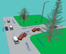
Grisly Details
At a crash or crime scene, virtually anything can be
evidence or a data point needing recording. Typical data points are street
signs, trees, vehicles, skid marks, and so forth, but they also include bodies
or body parts, bullet holes or shell casings, and drops or splatters of blood or
other fluids.
TDS Nikon Product Manager Daryl Stewart said the total station takes
measurements of its targets, making them data points, using pulse laser
technology and their natural reflectivity. "The instrument shoots out tens of
thousands of pulses at its target, and those pulses are reflected back to the
instrument, giving you the measurement," Stewart said, adding that because
natural reflectivity is lower as a target's color is darker (which becomes an
issue with dried blood or a highway's black asphalt), the system also works with
someone holding a prism next to the target, making the evidence gathering a
two-person job.
When investigators download all gathered data points, each of which is
assigned a symbol that AIMSLT is programmed to
interpret and represent as an image, the software essentially connects the dots,
or points, drawing the lines based on the measurements and mapping the scene in
seconds. Ideally, investigators will have a PDA or laptop with them on site so
when the map is made they can do a visual check, comparing the screen to the
actual scene.
Can I Get a Witness?
Billings, Mont., Police Department Detective Kon
Kunnemann, who began using AIMS only recently, said the effect the system has on
his job is significant. "It's much more accurate than a tape and so much
quicker," he said. "Our system is prismless. One guy can go out and take
measurements by himself, which is a big savings factor for the department, as
far as manpower is concerned. AIMSLT creates the
maps in a matter of seconds, then you get in and do the fine-tuning, making the
[generic] vehicle a Jeep and so on."
Officer Andy Collier with the Carlsbad, Calif., police department said he has
used the fine-tuned scene maps in court to see the successful conviction of both
a murder and vehicular manslaughter case. "Juries are impressed because it's not
just a hand-drawn diagram you're passing around," Collier said. "Instead, you've
got a diagram that takes up an entire wall."
CAD Zone, a provider of mapping software for law enforcement applications,
developed AIMSLT, which includes the complete
Crash Zone and Crime Zone software products that are designed specifically for
accident and crime scene mapping. Pelham, Ala., Police Department Officer David
Rushton, who had previously used the Crash Zone software, said AIMS is user
friendly and cost effective. "I sat down with the computer without even reading
the manuals and figured it out, and that's what we--and a lot of police
departments--need: something that's easy for everybody to figure out," he said.
"The more you use it, the quicker you get. I know it saves me a ton of time.
With the amount of money it saves not having to do overtime for the mapping, it
pays for itself."
Priced from $6,385, depending on the total station model selected, the
complete AIMS system is available in the United States from TDS-authorized
dealers. TDS is the U.S. distributor for Nikon survey products, including sales,
service, and support.
This article originally appeared in the November 2004 issue of Occupational Health & Safety.