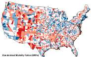
'Death Map' Provides Useful Emergency Planning Tool
University of South Carolina geographers have produced a map of natural-hazard mortality in the United States.
The map, featured in the Dec. 17 issue of the International Journal of Health Geographics, gives a county-level representation of the likelihood of dying as the result of natural events such as floods, earthquakes, or extreme weather.
Dr. Susan Cutter, a Carolina Distinguished Professor of Geography, and Kevin Borden, a doctoral candidate in geography, used nationwide data dating back to 1970 to create the map.
Cutter said the map will be a valuable planning and policy tool. "This work will enable research and emergency-management practitioners to examine hazard deaths through a geographic lens," she said. "Using this as a tool to identify areas with higher-than-average deaths can justify allocation of resources to these areas with the goal of reducing loss of life."
According to the data, hazard mortality is most prominent in the South, where most people are killed by severe weather, such as tornadoes. Other areas identified as having elevated risks include the northern Great Plains Region, where heat and drought are the biggest killers, and in the mountainous areas of the West, where deaths are attributed to winter weather and flooding. The greatest threats to the south central United States are floods and tornadoes.
Heat/drought ranked highest among the hazard categories, causing 19.6 percent of total deaths, closely followed by severe summer weather (18.8 percent), and winter weather (18.1 percent). Geophysical events such as earthquakes, wildfires, and hurricanes were responsible for less than 5 percent of total hazard deaths combined.
"What is noteworthy is that over time, highly destructive, highly publicized, often catastrophic singular events such as hurricanes and earthquakes are responsible for relatively few deaths when compared to the more frequent, less catastrophic events such as heat waves and severe weather (summer and winter)," Cutter said.
While the researchers said these findings may not be entirely surprising, they provide a valuable blue-print for identifying hazard mortality "hot spots" that merit in-depth study so that emergency-management officials can make plans to reduce the number of future deaths.
Cutter and Borden's article and map can be accessed at www.ij-healthgeographics.com.