
Virtual CSI
In forensics, precision is essential. This 3D scanner provides it.
- By Marc Barrera
- Mar 01, 2009
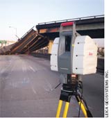 The first and most important objective in the hierarchy of controls is the elimination or substitution of a hazard. This principle was also the impetus for the creation of Leica ScanStation 2, which is manufactured by Heerbrugg, Switzerland-based Leica Geosystems AG. This mobile laser scanner features an embedded high-resolution camera and a high-definition, 3D laser scanning system that can quickly map an environment in 360 degrees, collecting 50,000 measurements per second to create a photorealistic view of any setting.
Having a Vision
It all began very simply. In 1993, Ben Kacyra, a San Francisco-based engineer, co-founded Cyra Technologies Inc. to develop a better way to survey and measure existing structures for retrofits. “Surveying technology up until the time that Ben came along was limited to pocket tape measurement, sketches, and total stations,” said Tony Grissim, public safety and forensic account manager at Leica Geosystems. “You typically had to go stand next to whatever it is you wanted to measure and touch it. If you’re trying to build something that’s 60 feet overhead, you would have to erect scaffolding and go to heroic efforts in order to get there and hand-measure whatever you’re trying to design around.” This process resulted in a lot of extra time and money, as well as unnecessary exposure to hazards.
Employing the same MIT Lincoln Laboratory laser that was developed for the Star Wars missile defense program and combining it with timing circuitry developed at Los Alamos National Laboratory, the initial model, Cyrax 2400, was created. “Somebody had developed this technology and kind of put it in a drawer,” Grissim said. “Ben went and turned it into a product.”
First Responder Forensics
Building on the capabilities of its predecessor, the ScanStation 2 was developed soon after Grissim realized the product had many first responder possibilities. Due to the volatile nature of this work, first responder forensics—such as arson or accident investigations— can be very time consuming and dangerous. According to Grissim, the ScanStation 2 minimizes exposure to these hazards and streamlines data gathering.
For example, Grissim noted, a crime scene at a methamphetamine lab poses many threats, including chemical exposure. “The ability to measure the scene completely, objectively, and remotely and not have to expose the crime scene personnel to biohazards is definitely a benefit,” he said. After the device has scanned the area, its Cyclone software patches together the data to create a 3D image of the scene, complete with measurement data.
This precise picture is accurate within a quarter-inch, is free from subjective human interpretations, and can be entered into evidence to verify witness statements or help to illustrate the scene in court. Also, with these data, investigators can virtually revisit the crime scene to take additional measurements or data without ever leaving their office.
Emergency Response
Often, first responders are called on to make immediate, tough decisions on how and when to proceed into an unknown, possibly hostile situation. The ScanStation 2 allows responders to make informed decisions at minimal risk to people.
In April 2007, the scanner proved its value after a gas tanker truck overturned and exploded at the MacArthur Maze, a large freeway interchange located near the eastern end of the San Francisco/Oakland Bay Bridge in Oakland, Calif. The intense heat from the fire caused the Interstate 580 roadway to collapse onto a section of freeway below. “They were able to quickly scan the entire large, collapsed structure, so then the demolition process could start almost immediately. It was within 24 hours that they had hired a contractor to start clearing away the rubble,” Grissim said. “Then Caltrans, the DOT in California, came out and did some scanning of the structure—or what was left, what was salvageable still. A third entity, the survey company that was hired to do quality control and stake out the new construction, used the laser scanning in order to make sure everything was fitting right. They had that road open in less than 30 days.”
The Department of Homeland Security also has realized the value of this device. Grissim said the agency has purchased two scanners in order to integrate them into some of its first responder courses at the National Center for Biotechnical Research and Training.
But response is not the only application for the product. As Grissim pointed out, the scanner can be used for threat assessment planning and preparation by measuring and modeling critical infrastructure. “The scanner’s long-range ability allows you to go in and measure, map, and model a downtown urban environment. So you can then figure out that if there was an event, where would you position your counterterrorism assets?” he said. “Being able to understand in 3D the exact dimensions of your environment just provides better information for the incident commanders to be able to make better-informed decisions by understanding what the existing conditions look like.”
This article originally appeared in the March 2009 issue of Occupational Health & Safety.