Red Cross Estimates Louisiana Flood Relief's Cost at $30 Million
Meanwhile, officials from the city of New Orleans urged residents to protect themselves and their homes from mosquitoes, which can transmit diseases such as Zika virus, West Nile, and chikungunya.
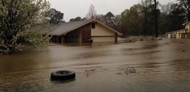
As residents try to recover from this month's floods in northern Louisiana, the American Red Cross estimates its relief work to provide feed, shelter, and comfort to thousands of people affected by the disaster will cost at least $30 million. ARC calls it the worst U.S. disaster since "Superstorm" Sandy and reports the relief costs may grow as information about the scope and magnitude of the devastation comes in
The Red Cross is asking the public to donate money to assist by visiting redcross.org, calling 1-800-RED CROSS, or texting the word LAFLOODS to 90999 to make a $10 donation. "Our volunteers are tirelessly working around the clock to help thousands of people in Louisiana," said Brad Kieserman, vice president of Disaster Services Operations and Logistics for the Red Cross, on Aug. 19. "Right now we are concentrating on providing food, shelter, and relief supplies. But with thousands of homes affected, our work is just getting started. We'll be there for the long run to help people recover from this historic disaster."
More than 1,500 Red Cross representatives from all 50 states and hundreds of local volunteers are part of the relief effort.
Meanwhile, officials from the city of New Orleans urged residents to protect themselves and their homes from mosquitoes, which can transmit diseases such as Zika virus, West Nile, and chikungunya. The threat is greater because recent heavy rainfall and high temperatures in New Orleans mean more mosquitoes are in the area. As of Aug. 19, no locally transmitted cases of the Zika virus in New Orleans or Louisiana had been recorded, but travel-related cases have been identified in New Orleans and elsewhere in Louisiana.
On Aug. 14, the National Geodetic Survey (part of NOAA) began collecting damage assessment photos of flooded areas identified by FEMA and the National Weather Service. These areas had experienced historically heavy rainfall. A team of NOAA aviators used remote-sensing cameras aboard King Air aircraft flying above the area between 2,000 and 3,000 feet. Aerial photos help in determining the extent of damage inflicted by flooding and are used to compare baseline coastal areas to assess the damage to major ports and waterways, coastlines, critical infrastructure, and coastal communities.