Washington State DOT Posts Bridge Height Trip Planning Tool
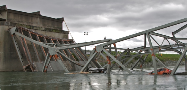
WSDOT was already updating its bridge clearance information when a truck impact caused part of the Skagit River Bridge to collapse in May 2013. The online tool is part of the department's response to that accident.
A new online tool created by the Washington State Department of Transportation will help truckers plan the safest routes and avoid bridge impacts, the department announced Jan. 15. The agency already was updating its bridge clearance information when a commercial truck hit the superstructure of the I-5 Skagit River Bridge on May 23, 2013, causing a span of the bridge to collapse. The newly collected bridge data "became a springboard to develop the state route bridge vertical clearance trip planner as part of WSDOT's overall response to the collapse," the department announced.
In November 2014, the Washington State Patrol cited the truck's driver, William D.W. Scott of Alberta, Canada, for Negligent Driving in the Second Degree, a traffic infraction carrying a fine of $550.
Washington Gov. Jay Inslee said the new trip planner "offers truckers a new tool to find the safest route for their trip. It applies lessons learned from the Skagit River Bridge replacement, and it will reduce the risk of collisions throughout the system."
The planner uses GIS mapping and shows drivers which bridges on their proposed route should be avoided or approached with caution because heights may vary by lane. The trip planner database will be available to third-party developers who have expressed interest in creating navigation apps.
"We've taken advantage of existing technology to help improve safety on our roads," said Transportation Secretary Lynn Peterson. "Sharing this data through private-public partnerships will help get this information into even more customers' hands."
The announcement said the trip planner was developed in consultation with the Washington Trucking Association, whose members did beta testing of it. "This is a huge step in the right direction," said Sheri Call, the association's vice president of government of relations. Up to now, drivers had to look up bridge data online or in a book and then consult their own maps, she said.
All state highway bridges with a minimum clearance of 16 feet, 6 inches and lower will be re-measured as part of a comprehensive statewide review scheduled for completion in late 2015, and the department plans to expand the trip planner features, including displaying lane-by-lane height information, by 2017.