Anticipating Weather Dangers
Advanced technology helps today's emergency responders keep their communities safe.
 Weather tools available to emergency responders
have improved considerably in
recent years. As important as National
Weather Service (NWS) watches and
warnings are, they’re just the starting point. You can now
access everything from detection of likely tornadoes to
real-time lightning and frost and icing forecasts. Reliability
and ease of use have improved. Emergency management
organizations are increasingly adopting these
weather tools to better prepare, respond, and recover.
Weather tools available to emergency responders
have improved considerably in
recent years. As important as National
Weather Service (NWS) watches and
warnings are, they’re just the starting point. You can now
access everything from detection of likely tornadoes to
real-time lightning and frost and icing forecasts. Reliability
and ease of use have improved. Emergency management
organizations are increasingly adopting these
weather tools to better prepare, respond, and recover.
Earlier, More Precise Warnings
Some weather Web sites and services now provide “storm
corridors”—radar-based indications of a likely tornado,
severe thunderstorm, or hail. Additional information,
such as the storms’ likely path, type, and overall direction
indicators, helps to provide an earlier alert.
As visual indications on a map, they’re
easy to interpret and far better than a non-meteorologist
trying to look at radar and
guess whether a tornado is on the way.
Storm corridors can be a valuable addition,
going beyond NWS warnings to help
emergency responders make a faster decision
to sound sirens.
In fall 2007, NWS completed enhancements
to its warning bulletin system whereby
more precise warning areas are provided
other than just county boundaries alone.
This system has been alternatively referred to
as storm-based warnings, community-based
warnings, or areas of maximum impact.
These more precise warnings give a localized
indication of where the greatest danger is for
tornados, severe thunderstorms, and floods.
They can help emergency responders to better
gauge danger and reduce “false alarms.”
Having these and traditional, county-based
warnings is a must for any public safety organization.
Real-Time Lightning Risk
Knowing when a storm also has lightning risk has been a guessing game, until now.
The latest weather services detect actual lightning in real time (within a minute)
and can even alert managers via their
phones and map individual strikes that are
happening within a specified coverage
area. Waiting to see lighting or hear thunder,
and then respond, is too late to properly
avoid the danger.
NWS recommends that the public get to
a safe place (in grounded buildings or in a car/bus) when
lightning is within six miles. By using lightning detection,
emergency responders know what’s to be expected and
can take proper safety action, without false alarms.
There’s time to sound alarms, clear swimming pools, get
golfers off the municipal course, and send park and
recreation participants to their cars, as well as providing
sufficient evacuation notice during civic events.
Be forewarned that any lightning detection maps
you’ll see on free Internet sites are delayed 30 to 60 minutes
and should never be used to make safety or evacuation
decisions. Like many of the new weather tools described
here, real-time lightning is available only from
subscription services but is remarkably cost effective.
Real-time lightning can also be useful for gauging fire
risk, especially in drought or fire-prone areas.
Snow and Ice: The Number One Killer
First responders, even those in the snow and ice belts of
the United States, sometimes do not consider winter
weather in the same category as tornados, floods, hurricanes,
and other weather risks. But recent Federal Highway
Administration data show that annually there are
more than 10 times as many weather-related road fatalities
as off-road weather fatalities (7,400 annually versus
650 annually). Some of these weather-related traffic
deaths are due to rain and fog, and many are winter related.
Winter-related fatalities are the ones that may be
the most preventable.
Advanced weather technology now can anticipate
frost on overpasses or icing on roads through the use of
pavement forecasts, enabling proactive salting and prevention.
Here’s where teaming up with the public
works/city or county department of transport is key.
Those responsible for winter road maintenance can purchase
pavement forecasts and take appropriate preventive
action while coordinating with public safety officials.
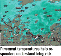
Emergency responders also can obtain current pavement
temperatures (as opposed to the forecasts just described)
to help gauge the risk of roads icing up because of sleet
or in overnight re-freeze situations. (It is pavement temperatures,
not air temperatures, that matter!)
Today’s emergency responders don’t have to wait for
accidents to happen and then respond. It’s now possible
to use accurate and reliable weather information to do a
better job scheduling staff for impending weather, while
at the same time reducing costs and increasing safety.
More Accurate, Timely Forecasts
Despite jokes about weather forecasts, the reality is that the
science behind weather forecasting has improved markedly
in the past decade. Weather vendors should be able to
provide independent, third-party verification of their fore cast accuracy. Another important innovation
is hourly updates of forecasts, as even the best
forecasts benefit from timely adjustment. Asking
your weather services provider about these
is the only real way to know.
A recent example of improved forecast accuracy
was the February 2008 tornados that
ripped through the Southeast, killing 60 people.
Unfortunately, some communities relying
on traditional weather sources were ill
prepared. The weather forecasts from at least
one major vendor predicted extensive tornados
and widespread, damaging wind gusts of
60-75 mph in the impacted areas roughly 20
hours before the storms hit. Early warning
meant local emergency responders had time
to prepare, mobilize, and save lives.
Emergency responders can obtain mid-storm
and post-storm radar-based rainfall
estimates to anticipate flooding. The estimates
can be highly localized so emergency
responders can visualize exactly where the
most rain occurred in local watersheds.
Such tools, along with better hourly forecasts,
can prove quite helpful in flood
preparation and safety response.
Hazardous Materials
Hazardous material incidents are another
area of emergency response that has a major
weather component. Whether the cause is a
warehouse fire, train derailment, tractor/
trailer accident, or other hazmat incident,
it’s important to know how weather will affect
the atmospheric plume from such
chemical releases.
For emergency response purposes, the
ideal approach is to have both a quick and
a comprehensive plume model—that is,
predictions of how wind speed, wind direction,
temperature, and other factors will
affect chemical drift. A quick plume model
will help emergency responders safely approach
the incident and begin community
evacuation. Then, a more complete plume
modeling that takes into account the chemical
involved, volume of chemical, localized
wind speed/direction, and so on—which
takes more time—is desirable for both the
safety of emergency personnel and the safety
of the community. Quick plume modeling
doesn’t replace a full-blown plume
model, but it helps to augment it for faster
and safer response.
Convenience and Mobility
Convenience and accessibility are important
practical considerations. Modern Web displays
use a “layered” approach, where emergency
responders can customize maps and
see only the localized weather they are interested
in, such as radar, watches, and warnings,
at the same time.
Accessibility includes mobile access.
While emergency responders may have a 911
center or other staff members who monitor
weather 24/7, some do not. In these situations,
automated alerts to the cell phones of
key police, fire, or other EMS staff are critical.
Seeing local radar, lightning, and other
weather events on their phones becomes highly valuable.
Emergency responders have seen tremendous
improvement in the weather tools and
technology available. The latest, most up-to date
weather technology can help to improve
community safety while helping emergency
responders react to threatening emergency
situations and weather hazards. Be sure to
check out what’s now available.
This article originally appeared in the June 2008 issue of Occupational Health & Safety.