NIST Touts Data's Role in Improving Wildfire Defense
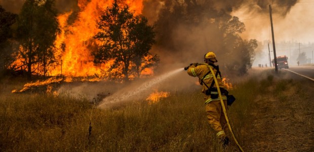
A NIST study examined three fires in February 2011 in suburban areas outside Amarillo at the wildland urban interface, the area where residential communities and undeveloped wildlands meet. Those fires destroyed 70 homes, burned more than 25,000 acres of land, and caused nearly $6 million in property damage.
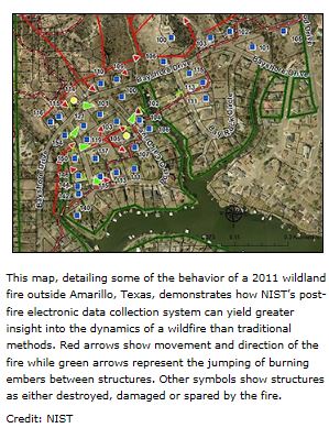
The National Institute of Standards and Technology has published a new study that analyzed a major 2011 Texas wildland fire using a rigorous, scientifically based post-fire data collection approach, a system the authors believe will lead to improved defensive measures and strategies for significantly reducing structural damage and property loss, NIST Senior Communications Office Michael E. Newman reported in an article posted to the NIST website. They created a map of some of the behavior of the 2011 wildland fire outside Amarillo and showed how NIST's post-fire electronic data collection system provides more insight into the dynamics of a wildfire than traditional methods. (On the map, red arrows show movement and direction of the fire and green arrows represent the jumping of burning embers between structures. Other symbols show structures as destroyed, damaged, or spared by the fire.)
 This work examined three fires in February 2011 in suburban areas outside Amarillo at the wildland urban interface (WUI), the area where residential communities and undeveloped wildlands meet, according to Newman's article, which says those fires destroyed 70 homes, burned more than 25,000 acres of land, and caused nearly $6 million in property damage. "What made these events different from other WUI fires was that—for the first time in an actual fire situation—researchers used a two-tiered electronic data collection methodology developed by NIST to assess post-fire conditions. This resulted in the most extensive amount of information acquired to date in the aftermath of a WUI fire, approximately 163 gigabytes of data and more than 29,000 photographs.
The massive amounts of data collected and analyzed were used in two separate NIST reports. The first, issued in July 2011, provided a reconnaissance overview of all three Amarillo WUI fires and identified the technical factors that may have influenced whether impacted structures were damaged or destroyed by the event, or survived," he explained.
This work examined three fires in February 2011 in suburban areas outside Amarillo at the wildland urban interface (WUI), the area where residential communities and undeveloped wildlands meet, according to Newman's article, which says those fires destroyed 70 homes, burned more than 25,000 acres of land, and caused nearly $6 million in property damage. "What made these events different from other WUI fires was that—for the first time in an actual fire situation—researchers used a two-tiered electronic data collection methodology developed by NIST to assess post-fire conditions. This resulted in the most extensive amount of information acquired to date in the aftermath of a WUI fire, approximately 163 gigabytes of data and more than 29,000 photographs.
The massive amounts of data collected and analyzed were used in two separate NIST reports. The first, issued in July 2011, provided a reconnaissance overview of all three Amarillo WUI fires and identified the technical factors that may have influenced whether impacted structures were damaged or destroyed by the event, or survived," he explained.
Newman writes that the latest study is NIST Technical Note 1909: 2011 Wildland Urban Interface Amarillo Fires Report #2—Assessment of Fire Behavior and WUI Measurement Science, which features a comprehensive documentation and analysis of one of the fires that is called the Tanglewood Complex Fire, including:
- A detailed timeline of the fire's movement and spread
- A record of the types and construction of structures that were affected or endangered by the fire
- A description of topographic characteristics and fuel sources, including vegetation and structural elements such as fences
- Observations of the fire's behavior
- An assessment of defensive measures in place before the fire
"The level of detail that can be obtained with our data collection system is significantly greater than traditional procedures that focus simply on the number of structures damaged or destroyed, without taking into account the underlying factors that actually cause the destruction," said NIST fire protection engineer and Amarillo study team leader Alex Maranghides. "Gathering as much data as possible in this strategic manner gives us unprecedented insight into how and why structures respond to WUI fires—and that knowledge could help us build more fire-resilient communities in the future."
According to Newman, WUI fires are increasing as housing developments encroach on wilderness areas. Nearly 39,000 homes were destroyed by wildfires from 2000-2012 and federal, state, and local agencies spent an average of $4.7 billion annually during that period on WUI fire suppression. About 72,000 communities and more than 120 million people are now at risk from these disasters.