Hand-held Disaster Relief
This rugged PC makes field work feel like a desk job.
- By Marc Barrera
- Dec 01, 2005
 THE place is a desolate, stinking, swampland speckled with the remains of a
past civilization. Upended cars and rooftops serve as makeshift perches for
birds who keep constant focus on an approaching alligator. Countless remnants of
the civilization that once called this place home poke up through the infested
waters, making one wonder what apocalyptic event caused this Atlantis to sink
below the water. It was a hurricane named Katrina and the city was . . . New
Orleans.
Chances are, if you were a Marine during the recovery effort, you were
witness to scenes similar to this one as it played out all over affected areas
of Louisiana, Mississippi, and Alabama. There was no conventional power source
to speak of and little stable ground for a proper base of operations. Time was
of the essence, and mobility was a premium. In this environment, equipment had
to perform the role of asset, not liability. One tool used by the Marines was
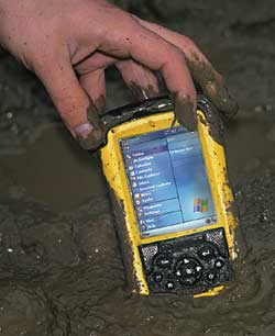
Tripod Data Systems' ReconTM, a rugged, portable
PC made for harsh environments.
Reconnaissance and Response
Michael Gray, president and CEO of Global
Relief Technologies, said the compatibility of the unit's Windows
MobileTM software, coupled with a military-rated,
waterproof shell, made it the perfect fit for his software. "It's just a really
durable tool and a very good platform for our rapid data management software
that we load on the Recons along with GIS mapping software," Gray said. "It was
used in places like Africa--in refugee operations there--Afghanistan, and
Iraq."
In the aftermath of Katrina, the Recon was used by the 2nd U.S. Marine Corps
Expeditionary Force and FEMA for emergency reconnaissance of bridge and road
conditions and the power infrastructure, Gray said. The device meets military
standards for drop, vibration, and temperature extremes, withstanding sand,
dust, high altitudes, and temperatures ranging from minus 22 degrees Fahrenheit
to 140 degrees Fahrenheit. It can be submerged as deep as one meter for 30
minutes. It has dual CompactFlash Slots and a standard 9-pin connector that can
be used to add peripherals, such as a GPS card or a satellite phone. Its
rechargeable PowerBoot module provides a minimum 15 hours of operating power
with default settings. (The unit can be powered by two AA batteries as a
backup.)
The Recon does have a few drawbacks. The stylus' holder on the back of the
unit beneath the hand strap may be difficult to navigate for a glove-wearing
user, and smaller government agencies might not be able to fit the price range
into its budget. One customer experienced short battery life but said TDS
corrected the situation.
Overall, its platform adaptability, ruggedness, and mobility have attracted
many software companies to bundle their product with the device. The result is a
large selection of mapping, hazmat, inspection, pre-hospital care, and even
surveying software that has persuaded many first responder agencies to include
the Recon into their budgets.
Multifunctional Capabilities
In North Carolina, Station Oregon Inlet
near Cape Hatteras won the Coast Guard's Capt. Niels P. Thomsen Award for Effort
in 2004 for its innovative use of the Recon. By installing a GPS card, a
satellite phone, and mapping software to the device, rescue time was cut by up
to 30 minutes, said Petty Officer Justin Schnute, who implemented the new
process. Crews could now immediately head in the direction of a rescue call as
search pattern information was e-mailed to them en route rather than wait at the
dock until such data was delivered. Also, an additional crew member was now free
to search the water rather than lay out charts and plot the course, as the Recon
attended to such tasks.
Integrating its Firehouse Software® with the device, the Denver Fire
Department now directly uploads inspection data to its database, eliminating
wasteful fire inspection paper forms and thousands of data entry hours.
In Eastern Oregon, the U.S. Army's Umatilla Chemical Stockpile integrated its
Recons into its hazmat response plans. Using specialized software, first
responders can access real-time data about present chemical threats, the
appropriate precautions necessary for containment, and the locations of other
response teams in the area, removing the need to carry a large, three-ring
procedure binder.
In 2004, STAT MedEvac, an air medical transport service, picked one of its
bases to test the Recon in order to cut down paperwork time between flights. The
device's adaptability allowed the base to use its software to start patients'
charts en route, freeing up downtime between response calls, said John Lovett,
base site coordinator. "Whenever you've dropped off the patient and you're
returning to base, or if you're on a fixed wing mission where you're sitting on
the aircraft for a couple of hours, [the Recon] allows you to do the charting
before you get back to base," Lovett said. "It really saves you a lot of time. .
. . We're putting on our protocols, policies, and things like that so whenever
you have a question while you're in the air, you can just look at the
Recon."
TDS, based in Corvallis, Ore., also offers a similar model called the
RangerTM that has additional features including a
keypad, a slimmer body design, and an integrated Bluetooth or 802.11b wireless
option. For more information, visit www.tdsway.com.
This column appeared in the December 2005 issue of Occupational Health
& Safety.
This article originally appeared in the December 2005 issue of Occupational Health & Safety.