CDC-Funded Imaging System Seeks to Help Disaster Response
Researchers at the Georgia Tech Research Institute (GTRI) have developed a low-cost, high-resolution imaging system that can be attached to a helicopter to create a complete and detailed picture of an area devastated by a hurricane or other natural disaster. The resulting visual information can be used to estimate the number of storm refugees and assess the need for health and humanitarian services.
According to the study, aid organizations currently don't have a quick and accurate way to determine how many people need assistance. Satellites can collect images of areas affected by a natural disaster, but there are dissemination restrictions and cloud cover can prevent collection of images.
"Without a real-time map, it's very hard to do population estimates and demographic estimates to figure out where people are, how they're moving, how they're spaced out and even how many people you have on the ground," said Benjamin Sklaver, a project officer from the Centers for Disease Control and Prevention (CDC) International Emergency and Refugee Health Branch. "This technology does not exist currently, so GTRI's imaging system is really an innovative project."
The imaging system was developed with funding from CDC, and agency officials would like to begin using this device as soon as possible. After responding to the recent devastation caused by Hurricanes Hanna and Ike, CDC asked GTRI to accelerate delivery of the imaging device for use during the 2008 hurricane season.
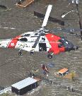
"We plan to package the system for use on Coast Guard UH-60J Black Hawk helicopters, which were among the first to fly over Haiti following Hanna's devastation," said David Price, a GTRI senior research technologist.
The imaging system--designed by Price and senior research engineer Gary Gray--is called the "Mini ModPOD," which stands for "Miniature Modular Photographic Observation Device." It consists of an off-the-shelf Canon Digital Rebel XTi digital camera, a global positioning system receiver, a small circuit board that uploads mission parameters, and an inertial measurement unit that measures the aircraft's rate of acceleration and changes in rotational attributes, including pitch, roll, and yaw. The images collected from the system can be stitched together to create a complete picture of the affected area.
The research team has tested the device on several flights, selecting areas with large populations of people likely to be outdoors.
After the first flight, the researchers reduced the weight of the device and developed a more accurate geo-referencing capability, which allowed the physical location of the scenes shown in each photograph to be determined with precision. With the modifications made, the researchers went for a second flight test in July. The photos were successfully matched to the flight data, which enabled CDC to adjust them for geospatial reference. However, due to a software glitch, they were not overlapped as planned. The researchers made a small adjustment to the software and completed a third test flight in August.
"This flight resulted in images that were 60 percent overlapped, enabling CDC engineers to build a high-resolution mosaic image," Price said. "Individuals on the ground were easily distinguishable as people separate from other objects."
The imaging system will also be available to the CDC and other agencies, such as the American Red Cross, to count people in refugee camps in order to plan for health and humanitarian services.