SR 530 Landslide Commission Completes Report
Washington State Gov. Jay Inslee thanked the commission's members and staff for their work, as well as affected residents and first responders. He is proposing a transportation package that includes $36 million for landslide mitigation measures, funding for advanced LiDAR imagery, and risk analysis for priority areas.
A state commission appointed to investigate the March 22, 2014, landslide in Oso, Wash., submitted its final report Dec. 15, including in it 16 recommendations for items such as conducting landslide investigations and establishing a geologic hazards resilience institute. Listed first among the recommendations in the SR 530 Landslide Commission's report is integrating and sustainably funding Washington's emergency management system, and that Gov. Jay Inslee appoint a task force to come up with recommendations "to build a more robust and innovative system of response and to secure an adequate, sustainably funded management system across the state."
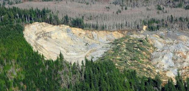
A previous report about the landslide called it the deadliest landslide in U.S. history, having killed 43 people. That report, issued in September 2014, estimated the landslide was 7.6 million cubic meters in size, or about 270 million cubic feet, and stated that it destroyed an entire neighborhood of about 35 single-family residences and covered a section of State Highway 530 with as much as 20 feet of debris.
Inslee's office issued a statement in which the governor thanked the commission's members and staff, as well as all residents of the Stillaguamish Valley, first responders, and others involved in the landslide and the investigation. "We cannot undo the loss of 43 Washingtonians, but the commission's work should stand as a tribute to the community's resilience and compassion," Inslee said. "While I have just received its final report, I am pleased to say that we are already moving forward on some of the recommendations. The transportation investment package that I will announce in greater detail tomorrow includes $36 million for landslide mitigation measures, funding for advanced LiDAR imagery, and risk analysis for priority areas. It also funds statewide GIS mapping and creates a Hazard Identification Institute to be the central clearinghouse for geological hazard information in Washington.
"Finally, it makes us all safer by funding an Emergency Management Task Force that will ensure the right talent and resources are delivered as quickly as possible to future disasters—whatever they may be," he said. "I look forward to further review of the commission's report and will be working with the 2015 Legislature on advancing key recommendations."
The commission's members were:
- David Montgomery, professor of Earth and Space Systems at the University of Washington
- Wendy Gerstel, a licensed hydrogeologist and principal at QWG Applied Geology
- Bill Trimm, FAICP, former Community Development director at the City of Mill Creek
- Diane Sugimura, director, Department of Planning and Development, City of Seattle
- Greg Garcia, former fire chief of the City of Pasco
- Steve Strachan, City of Bremerton police chief and former King County sheriff
- Lee Shipman, Emergency Management director at Shoalwater Bay Tribe
- Jill Boudreau, City of Mount Vernon mayor
- Renee Radcliff Sinclair, former state representative and former Snohomish County planning commissioner
- Paul Chiles, real estate counselor and former chair, Urban League of Metropolitan Seattle
- JoAnn Boggs, president, Washington State Emergency Management Association
- John Erickson, former director of Emergency Preparedness, Department of Health