Oso Report Recommends Landslide Warning Systems, Seismological Recordings
The Geotechnical Extreme Events Reconnaissance Association team's report, published July 22, analyzes the March 2014 landslide that killed 43 people in Oso, Wash.
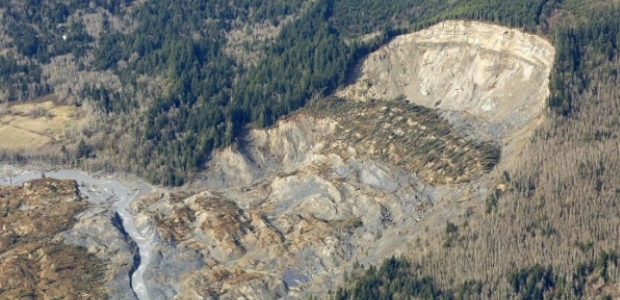
A new report analyzes the March 22, 2014, landslide in Oso, Wash., and makes recommendations for predicting and mitigating the damage caused by such landslides. The Oso event occurred about 10:37 a.m. on a Saturday. It killed 43 people, making it the deadliest landslide in U.S. history, according to the report prepared by a team from the Geotechnical Extreme Events Reconnaissance Association and published July 22, two months after the team's field reconnaissance. The National Science Foundation supported their work.
The landslide was 7.6 million cubic meters in size, or about 270 million cubic feet, and the debris flow traveled more than half a mile across a river valley, destroying an entire neighborhood of about 35 single-family residences and covering a section of State Highway 530 with as much as 20 feet of debris. The report notes that the slope that collapsed had slid several times since the 1930s, and it is "also the site of an ancient landslide."
"Records indicate no significant seismic activity in the days preceding the landslide and therefore it is unlikely that it had a siesmogenic origin," the report states. "Instead, it is highly probable that the intense 3-week rainfall that immediately preceded the event played a major role in triggering the landslide." It discusses additional factors, including the weakening and changing of the landslide mass by previous slides. "Given the size and depth of the landslide, if timber harvest practices did influence the landslide, it was through modification of the groundwater recharge regime rather than by any shallow-depth loss of root mass reinforcement," it states.
The report's recommendation section suggests communicating landslide risks clearly and consistently to the public, implementing monitoring and warning systems, and making seismological recordings of landslides – especially large ones -- to help in understanding failure sequences.